A Platform for Building the Open Metaverse

Every network and organizational effort is unique in scope and practice, but we all share the need for robust communication solutions that enable us to connect together, store & share information, and to manage relationships & critical resources. In this way, technology platforms have made decisive improvements for those of us who have access to them, keeping us connected and informed through the information we share. But is that access guaranteed in the future? Can we confidently say that we have robust and efficient solutions for backing up, securing, and developing human accessible information systems?
As we have described previously, there are immense social and economic risks associated with systems that compromise our individual identities, the content we share, and information pathways (lines of communication) that we use. But let’s also acknowledge the basic reality that paper ledgers and hand drawn maps are not a viable solution for managing the complex set of problems faced by people around the world. I won’t name them all, but let’s add some context.
PRIVACY & EDUCATION
The new battlefield is the mind, as well as the internet of things (IoT). Stuxnet ushered in a new era of attacks, which ranges from smart devices in your home, schools, to the national power grid. A new kind of operating system is needed to insulate networks and devices from bad actors, while also providing the tools needed to explore and pass on archival knowledge.
COMMERCE & LOGISTICS INFRASTRUCTURE
We live and work in data dependent environments that are going online, and getting smarter. Architects are incorporating Building Information Modeling, or BIM, into their plans. Civil engineers are planning smart cities. Service companies are collating data and attaching information to spaces. A new kind of OS is required to balance local governance and commerce in communities with privacy and accessibility.
Realtime Collaboration and Information Exchange
The Web we use today is not private, reliable, or free from exploitation. It lacks a way to preserve and access our digital records through time and space. Decentralization and p2p distributed systems offer resiliency and efficiency for the end user, while 3D interfaces offer whole new modalities of interactive expression. By distributing data, processing, hosting, and development across millions of computers and communities worldwide with no centralized control of data flows, a new Distributed Spatial Web has the potential to be truly open and accessible, empowering users around the globe to access, control, and protect their own personal data much better than ever before.
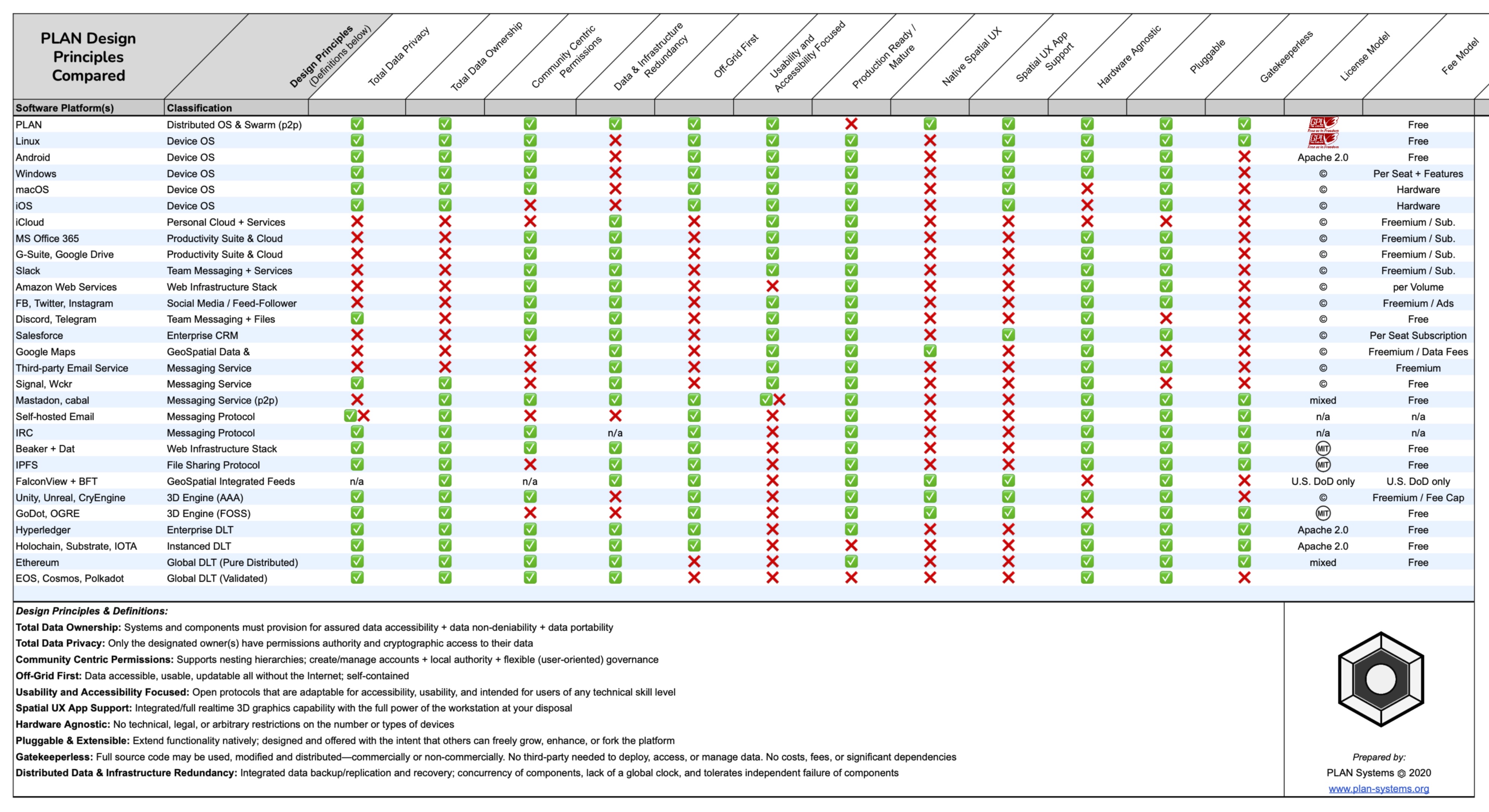
From our perspective, such a system requires a thoughtful examination of the principles and the technology stack that support our vital lines of communication. The framework must enable community and user-centric privacy, large file storage, communications capabilities, and the ability to easily host & maintain collaborative spaces to help power the logistics of societies. While this may sound like a huge undertaking (it absolutely is), the stakes are too great to ignore the need for a development framework that prioritizes digital privacy, ease of access, peer-to-peer collaboration, and data ownership.
– User & Community-Centric Privacy
– Data Ownership and Portability by Design
– Data Redundancy and Archival Storage
– Off-Grid Capable Tools for Logistics, Communications, and Archival Knowledge
– Gatekeeperless Infrastructure & Interfaces that are Accessible and Non-Technical
– Modular & Pluggable Components, A Platform You Can Build On and Extend
– Spatial and Immersive Experiences Enabling Real-Time Collaboration and Decision Making
– Hardware Agnostic, Open Source Flexibility
PLAN Systems exists to bring together developers, designers, artists, educators, engineers, and communities in order to solve challenges in human communications, logistics, and self-organization; in cooperation with sponsors, partners, and contributors to a new framework for technology solutions.
If you think the tools we rely on to connect to each other can be better, let’s build the community supported web & operating systems that we deserve.
Featured Video Text Description for Persons with Vision Impairment or Low Vision
Video Introduction: PLAN Systems logo displayed in front of a rolling grid of hex tiles
- “Introducing PLAN 3D” Close up displaying PLAN 3D on a desktop computer
- Showing close up shots of two people collaborating together on a desktop Mac and Windows laptop workstations, both with a 3D map of Austin Texas on their screens
Part 1 “Collaborate in Virtual Spaces”
- Showing a full screen view of the 3D Austin Texas map panning across downtown with a giant video billboard and a space themed sky scape.
- Cut to a 3D desktop Space with the PLAN logo, two side by side chairs, a TV, and an elephant in the room. Clicking the elephant launches a talk channel, demonstrating the ability to multitask with the tabbed interface
- User scrolls through past messages while also still able to access the original Space
Part 2 “Design 3D Presentations”
- Showing the user in a Solar System space with the Sun and the planets in a row in the scene. The user clicks on three of the planets to reveal the system interface panels that stack on top of each other, enabling access to settings & links embedded in the 3D models.
- Cut to the PLAN interface laid out in 4 columns across the screen, demonstrating the web view browser and the monitoring of multiple spaces and channels in a custom arrangement
Part 3 “Mission Critical Applications with Realtime Interfaces and Modeling”
- Showing a demonstration of placing terrain in an empty space (example: the mushroom farm 3D satellite imagery)
- Fades to a forward panning shot of an emergency rescue scenario on the hill side of the farm compound. Includes fire and medical assets, including a helicopter, active fires, fire fighters on scene, nurse and patient, blue smoke, fire truck, ambulance, and direction arrows with motion.
Part 4 “Interactive Environments allow you to Add Labels, Channels, and Links to any location”
- Showing a fly through of various spaces in PLAN, including Stonehenge, Terrain map of the World, a 3D map of San Francisco, Rick & Morty Garage, Great Pyramid, Tibetan Temple mountain scape, and a close up fly-by of the mushroom farm helicopter at the drum roll.
Conclusion: “For PLAN 3D (alpha) access visit plan-systems.org“
- Showing a close up of the Tibetan Temple, the camera launches upwards to slowly reveal 6 different kinds of terrain maps all laid out together in the space as stars subtly twinkle in the sky.
- Cut to slow forward panning on the Austin Texas scene with two video billboards which are playing PLAN Systems videos.
PLAN Systems – Technology 501(c)(3)
Our work is community supported so if you enjoyed this content, please consider sharing with others. You can follow us on our website, Facebook or Vimeo. If you would like to support development, contribute via PLAN Systems’ website, Givebox or PayPal. The best way to make sure you see the content we publish is to subscribe to the mailing list. For more info about PLAN Systems and what we are trying to do with this platform, click here.
Contact admin@plan-systems.org for a demo, sponsorship info, or service requests. PLAN Systems is a non-profit 501(c)(3) dedicated to education, science, and economic development.
Propose a Project: https://www.plan-systems.org/proposal/
Developing tools for science & education, humanitarians, organization management, and digital instruments that enable realtime collaboration. Sponsors and Partners in development are welcome and essential.
Homepage: https://plan-systems.org
Why PLAN? https://www.plan-systems.org/charitable-purpose-faq/

Music by ArtIsInFormation, Song: Journey Swells: